Math/Social Studies:
Building Map Coordinate Skills
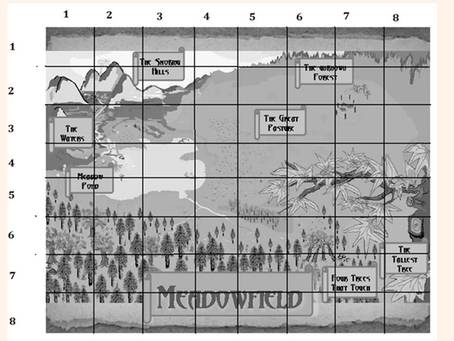
Using a grid map of Meadowfield, such as the one to the right, students give coordinate pair answers, practice cardinal and intermediate directional terms, learn about the compass rose and estimate scale.
Florida State Standards aligned with this activity:
*SC.2.L.17.2 Recognize and explain that living things are found all over Earth, but each is only able to live in habitats that meet its basic needs.
*SS.3.G.1.2 Review basic map elements (coordinate grid, cardinal and intermediate directions, title, compass rose, scale, key/legend with symbols) *SS.4.G.1.4 Interpret political and physical maps using map elements (title, compass rose, cardinal directions, intermediate directions, symbols, legend, scale, longitude, latitude).
*MAFS.5.G.1.1 Use a pair of perpendicular number lines, called axes, to define a coordinate system, with the intersection of the lines (the origin) arranged to coincide with the 0 on each line and a given point in the plane located by using an ordered pair of numbers, called its coordinates...
*SS.6.G.1.5 Use scale, cardinal, and intermediate directions, and estimation of distances between places on current and ancient maps of the world
It is recommended that this activity is NOT presented to the student until the student has finished reading at least the first two sections of A Pilgrimage of Pests.
At the end of this page, a button link is provided for grid maps and corresponding activity sheets which the parent/teacher can copy and reproduce for this lesson. Two grid maps are provided, one with letters on the Y axis and the other with numbers. An answer key is included.
Building Map Coordinate Skills
Using a grid map of Meadowfield, such as the one to the right, students give coordinate pair answers, practice cardinal and intermediate directional terms, learn about the compass rose and estimate scale.
Florida State Standards aligned with this activity:
*SC.2.L.17.2 Recognize and explain that living things are found all over Earth, but each is only able to live in habitats that meet its basic needs.
*SS.3.G.1.2 Review basic map elements (coordinate grid, cardinal and intermediate directions, title, compass rose, scale, key/legend with symbols) *SS.4.G.1.4 Interpret political and physical maps using map elements (title, compass rose, cardinal directions, intermediate directions, symbols, legend, scale, longitude, latitude).
*MAFS.5.G.1.1 Use a pair of perpendicular number lines, called axes, to define a coordinate system, with the intersection of the lines (the origin) arranged to coincide with the 0 on each line and a given point in the plane located by using an ordered pair of numbers, called its coordinates...
*SS.6.G.1.5 Use scale, cardinal, and intermediate directions, and estimation of distances between places on current and ancient maps of the world
It is recommended that this activity is NOT presented to the student until the student has finished reading at least the first two sections of A Pilgrimage of Pests.
At the end of this page, a button link is provided for grid maps and corresponding activity sheets which the parent/teacher can copy and reproduce for this lesson. Two grid maps are provided, one with letters on the Y axis and the other with numbers. An answer key is included.
